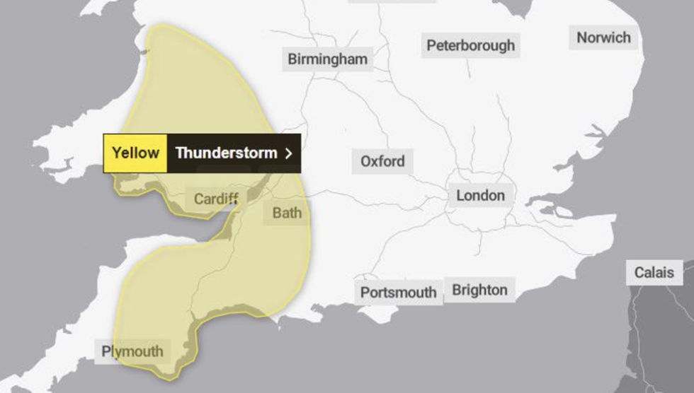
The Met Office has issued a thunderstorm warning for parts of England and Wales today, with slow-moving heavy showers and thunderstorms expected to develop across parts of Wales and southwest England this afternoon.
The yellow weather warning is in place from 1pm until 8pm on Saturday, with sudden flooding and disruption expected in places, as well as difficult driving conditions. The affected areas include a large part of Wales and southwest England.
According to the Met Office, some areas could see 20-30 mm of rainfall in just two hours, with a chance of up to 50 mm falling in a small number of areas. This could lead to temporary flooding of roads and potentially isolate some communities.
Showers and thunderstorms are expected to gradually fade during Saturday evening.
The Met Office advises people to consider whether their location is at risk of flash flooding and to prepare accordingly. This includes preparing a flood plan and an emergency flood kit, securing moveable objects such as bins and garden furniture, checking road conditions before travelling, and preparing for power cuts by gathering essential items such as torches and batteries.
Last Saturday saw the hottest day of the year so far, followed by dramatic thunderstorms the next day. Lightning storms also occurred overnight on May 2, affecting parts of southern England and South Wales.
Stay updated with the latest weather forecast and advisories from the Met Office to ensure your safety and preparedness during these weather conditions.