Double Storm Warning Hits the UK
The UK is bracing for a drenching this weekend as the remnants of two tropical storms, Humberto and Imelda, gear up to batter the nation with relentless rain and fierce winds. The Met Office has issued a severe weather warning lasting three days starting Wednesday evening, with western england/england/scotland-england/”>scotland/”>scotland-england/”>scotland/”>Scotland expected to bear the brunt.
[block_2]
Senior meteorologist Marco Petagna warned of staggering rainfall: “Ten inches of rain not out of the question Overover the highest ground in western Scotland… pretty incredible rainfall totals.” That’s a whopping 250mm soaking in just a matter of days.
When and Where the Storms Will Hit
- Warning in effect from 5pm Wednesday until 6am Friday.
- Western Scotland, northern areas near ireland/”>ireland/”>Northern Ireland, including Glasgow and coastal regions northward, are most at risk.
- Persistent heavy showers to lash Northern Ireland, western Scotland, and northwest England throughout the Weekweek.
Met Office Deputy Chief Meteorologist Chris Bulmer said: “Rain will be particularly persistent in western Scotland from Wednesday onwards, with 50-75mm expected across a wide area and over 100mm on west-facing mountains. Wind will also increase from late Thursday, especially on exposed western coasts. From Friday into Saturday, Humberto and Imelda could bring very strong winds and further heavy rain, though the exact track remains uncertain.”
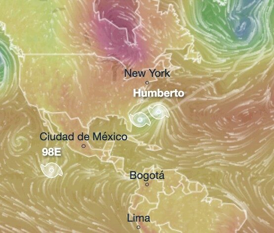
Humberto and Imelda: The Dangerous Duo Brewing Off the Atlantic
Hurricane Humberto, now near Bermuda, is predicted to edge towards the UK this weekend after regaining hurricane strength. Meanwhile, Tropical Cyclone Imelda, which has already caused chaos in Florida and deadly floods in Cuba, might combine forces with Humberto, forming a volatile storm system threatening unexpected force near the UK.
Read more from Glasgow.