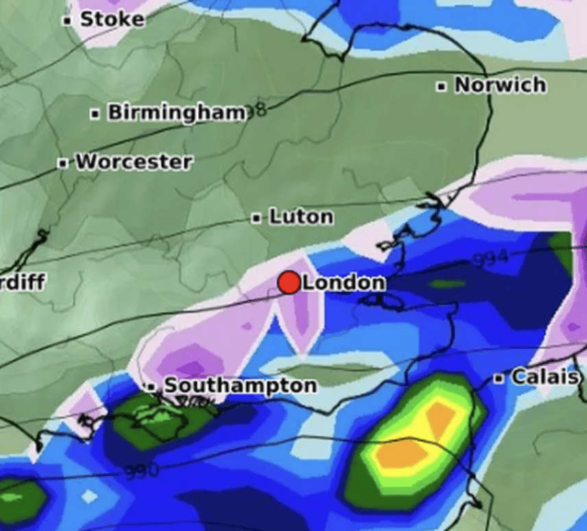
As London continues to grapple with a deep freeze, the city is bracing itself for a fresh wave of snowfall, expected to arrive on Wednesday, January 17. Forecasters are predicting light snow showers and sleet to envelop the capital, further intensifying the wintry conditions.
The imminent cold snap is set to plunge temperatures even lower, with Monday, January 15, expected to be the coldest day of the week. Parts of London could see the mercury drop to -2°C, making it feel more like a bone-chilling -5°C, according to the Met Office.
Meteorologist Alex Burkill, in a recent Met Office forecast, cautioned that the approaching week will bring a spell of “very cold” weather to the entire UK, potentially accompanied by “significant disruptive snow” in central and southern England.
As we look ahead towards the new working week, we do have that cold arctic air across pretty much the whole of the UK as we go through Sunday night into Monday, so a cold week is on the cards,” Burkill emphasized. We are likely to see further snow showers piling down in exposed areas, particularly towards the north, perhaps the east.
Additionally, an area of low pressure is expected to sweep in from the southwest, increasing the likelihood of “significant disruptive snow” in central-southern regions, although the exact locations and timing remain uncertain.
The recent bout of snowfall in the UK prompted an amber health alert from the UK Health Security Agency, which covers north-west England, the West Midlands, East Midlands, and south-west England. This alert is set to remain in effect until noon on Friday, indicating that “cold weather impacts are likely to be felt across the whole health service for an extended period of time.”
Mayor Sadiq Khan activated an emergency protocol earlier this week to provide shelter to rough sleepers as temperatures plummeted. An ice warning was also issued for London, in place until 3 am on Tuesday, following the city’s first snowfall of the year.
Reports of snowfall were confirmed in various parts of London, including Orpington, Croydon, and Beckenham on Monday morning. As the day progressed, the temperature dropped further, making it feel as cold as -5°C in some areas.
The ongoing frigid conditions result from high pressure systems ushering in colder-than-average weather for this time of year. The Met Office warns of potential “disruptive snow” next week, primarily impacting Scotland and Northern Ireland, but with the possibility of significant snowfall elsewhere.
Met Office Deputy Chief Meteorologist David Hayter explained, “While the initial snow risk from Sunday onwards is looking most likely to be coastal areas in the north of the UK, including North Sea and Irish Sea coasts, there’s an ongoing likelihood of some disruptive snow through the middle to latter part of next week.
The exact locations and intensity of the snowfall will depend on the interaction between the cold air currently in place and the moist, warm air coming in from the southwest. Meteorologists are closely monitoring these factors to provide more detailed forecasts in the coming days.
As Londoners prepare for the wintry weather, authorities advise residents to stay updated on weather alerts, take necessary precautions, and be prepared for possible disruptions to travel and daily routines.