
Forecasters are closely monitoring a developing Atlantic low which could bring damaging winds and heavy rain to southern parts of the UK late on Thursday and into Friday.
The latest forecast guidance continues to show uncertainty over the exact track and intensity of the system, but southern England and Wales currently appear most at risk.
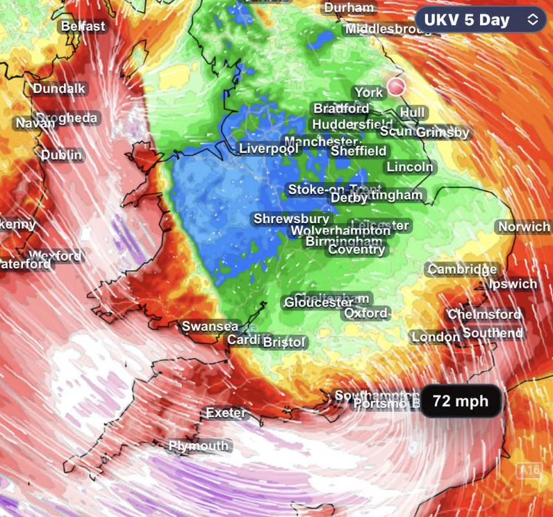
The Met Office has already issued a yellow warning for wind covering parts of southern England and Wales from midnight until midday on Friday, 23 October. It says gusts of 50 to 60mph are possible, with speeds potentially reaching around 70mph in exposed coastal areas.
Models suggest potentially stronger gusts
Some weather models are currently showing a more southerly track, which could place south-west England, Channel coasts and the Channel Islands closer to the strongest winds.
Individual model runs have indicated possible peak gusts of around 75 to 85mph in some exposed areas, with potentially stronger winds across parts of the Channel Islands and northern France.
Those figures are model projections rather than an official forecast, and could change significantly as the system develops.
Wales and Irish Sea coasts could also experience a period of disruptive winds.
Exact track remains uncertain
The position of the developing low remains crucial.
A slightly more northerly track could bring stronger winds across a wider area of England and Wales, while a shift south towards France could substantially reduce the impact on the UK.
The Met Office says there remains uncertainty over both the depth and position of the low, with the strongest winds dependent on its eventual track.
Deputy Chief Forecaster Tom Crabtree said forecasters were concentrating on a potentially deep area of low pressure expected to cross the UK overnight on Thursday and through Friday.
Friday is currently expected to be widely wet and windy before the low clears into the North Sea later in the day.
Residents in southern and coastal areas are being advised to keep checking forecasts and weather warnings as confidence increases over the next 48 hours.