Brits Face Bank Holiday Washout as Storms and Floods Loom
The Met Office has slammed the UK with storm warnings, forecasting heavy rain, powerful thunderstorms, and dangerous lightning strikes today. Britons are on high alert for a soggy bank holiday weekend that could put a dampener on outdoor plans.
Scorching Temps Mask Storm Trouble
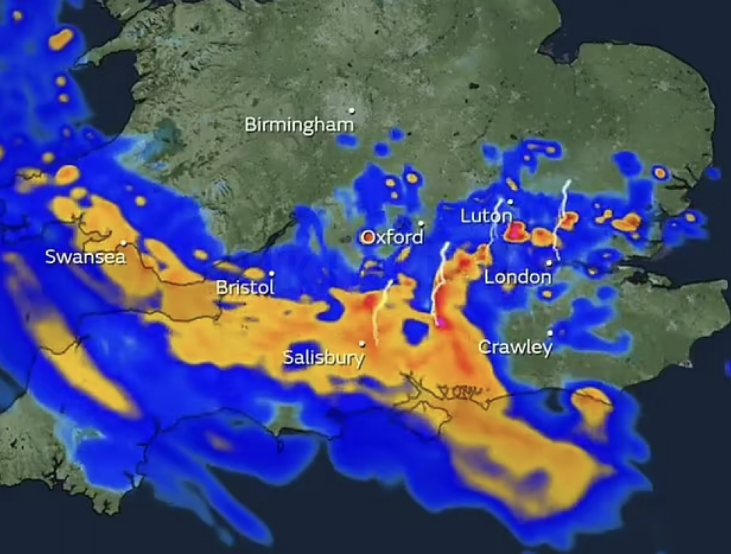
Despite soaring temperatures hitting 20°C (68°F) in the South and expected to nudge 22°C (72°F) tomorrow, spring’s unsettled mood refuses to settle. Central and southern England, alongside Wales, are set for fierce thunderstorms tonight that could blast the early hours of tomorrow with lightning and hail.
Met Office Issues Severe Weather Warnings
- South West England and Wales: Thunderstorm alert from 8pm tonight to 8am tomorrow, with up to 50mm (2 inches) of rain flooding down in just 2-3 hours.
- South East England: Warning active from 11pm tonight until 6am, expecting up to 25mm (1 inch) of rain in 1-2 hours.
The Met Office warns these storms may cause flooding, disrupt travel, cut power, and batter buildings with strong winds.
Bank Holiday Outlook: Mixed and Moody
Despite grim weather, the full bank holiday weekend remains a weather roulette. Showers and rain will sweep in from the west, with temperatures swinging across regions. The flypast for King Charles III’s coronation teeters on the edge due to these dodgy conditions, says the Ministry of Defence.
Long-Range Forecast: Showers and Sunshine
Looking ahead to May 14, expect a patchwork of showers mixed with dryer spells creeping in away from the northeast. Temperatures will hover slightly above average, with the South enjoying the sunniest skies while the North and East face more clouds.
Flood Alerts Still Active
The Environment Agency keeps 54 flood alerts active across England, mainly west and north of London, keeping communities on edge. Meanwhile, bookmaker Ladbrokes has slapped 4/1 odds on this May becoming the wettest on record — spring’s weather gamble is far from over.