The Met Office has issued an urgent thunderstorm warning for London and South East England starting from 12pm today, raising concerns about flash floods, power outages, and significant travel disruptions for millions across the region.
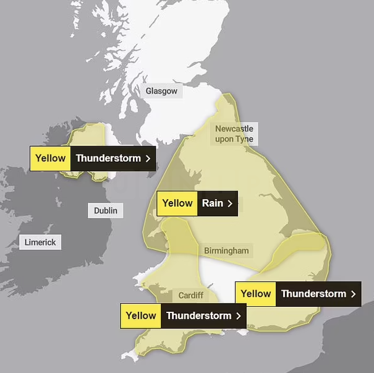
The 12-hour warning covers areas including Greater London, Sussex, Kent, Hampshire, and Surrey. Forecasters predict that flooding and lightning strikes could severely disrupt train and bus services, with up to 30mm of rain expected to fall within just one hour. Some areas might experience as much as 40-50mm of rainfall in a span of two to three hours.
Severe Weather Impacts
In addition to heavy rain, the severe weather is expected to bring hail and strong winds, which could cause power cuts and disrupt business operations. The Met Office has also issued a yellow warning for rain, effective tomorrow, for much of the east and west coast of England. The heavy rainfall could pose a danger to life due to potential flooding.
Thunderstorms are forecasted to hit Northern Ireland and parts of the South later today, possibly resulting in flooding and travel disruptions. In London, visitors at the RHS Chelsea Flower Show and walkers on Wimbledon Common are already bracing for the wet weather, seeking shelter under umbrellas.
The yellow thunderstorm warning for the South West, including London, is in effect from 12pm to 11:59pm today. Additional warnings are in place for Cornwall, Devon, Dorset, Plymouth, Somerset, Torbay, and parts of western Northern Ireland until 9pm tonight. Up to two inches of rain could fall within a few hours in these regions, accompanied by frequent lightning strikes and hail.
Travel and Safety Advice
The Met Office has advised that people should prepare for possible spray and sudden flooding, which may lead to power cuts, transport cancellations, and damage to buildings. Yesterday’s sunny spell, with temperatures reaching up to 22°C, has given way to today’s severe weather conditions.
Upcoming Weather Warnings
A yellow weather warning for rain across North Wales, the Midlands, and Northern England will come into effect from 12:15am tomorrow, lasting until 6am on Thursday. Scotland’s south and northeast regions will also experience a yellow warning for rain from 12am Wednesday until 6pm Tuesday.
Met Office forecaster Amy Bokota stated, “The downpours could be slow-moving, and that’s the main trouble. The wind’s quite light at the moment, so when they do form, they could be quite slow-moving and intense. Where you see them, they could be quite intense and dramatic, but not everywhere’s going to see them and some places just down the road could be completely fine and shower and thunderstorm-free.”
Looking Ahead
An area of low pressure is expected to approach the UK from the east on Wednesday, bringing heavy, prolonged rainfall to eastern parts of the country. This weather system is likely to continue moving along the east coast into Thursday, with southern Scotland and Northern England potentially experiencing further rain and gusty north-westerly winds.
Deputy Chief Meteorologist Dan Rudman said on Monday, “Low pressure is going to influence our weather from the middle of this week, bringing some heavy rain to parts of the UK. Eastern areas are most likely to see the highest rainfall accumulations, though this will depend on the precise positioning of the low pressure. It is important to keep an eye on the forecast as the detail becomes clearer, and it is possible Severe Weather Warnings will also be issued.”
Further rain is anticipated leading into the bank holiday weekend, with another band of rain likely arriving from the west, impacting Northern Ireland and moving east across the rest of the UK.
Stay tuned for updates and follow the Met Office’s guidance to stay safe during this severe weather event.